

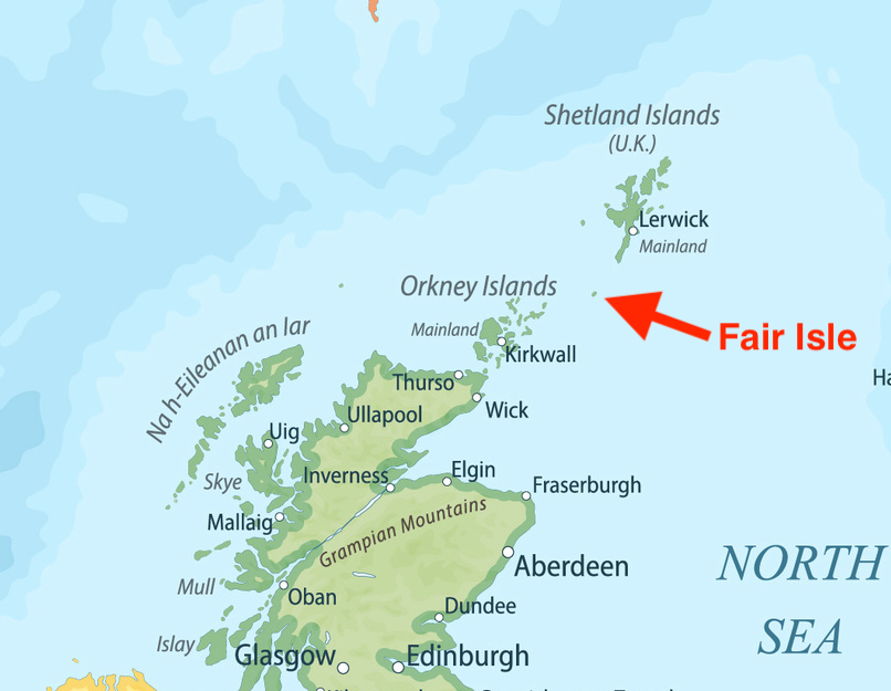
After spending many weeks sailing the coastline and fjords of Norway, it was a great change of venue to experience Scotland and their northern outpost – the Shetland Islands. Closer to the mainland of Scotland is another island group – the Orkney Islands – which is conveniently on the southbound path that we had spec’ed out in our planning over the winter. The two island groups are about 40 nautical miles apart, making the passage easy to do in one day. However, half way in between is a small but tantalizingly named spot called Fair Isle. It is known for its teeming birdlife and rugged angular cliffs with a background that is so typical here in Scotland – wide open, green pasture accented by tiny white dots. These dots, as you get closer, transform into casually grazing flocks of sheep. A small supply ship makes runs from Shetland to Fair Isle’s only protected harbor, North Haven, where individuals from a substantial bird observatory reside. Well, that is until the structure suffered damage from a fire and has been undergoing reconstruction for several years, surely on a slower timetable than on the mainland due to the challenge of ferrying supplies out to this remote location.
With a helpful forecast of winds from the West for the next two days, we set out at 6am from Lerwick eager to figure out what Fair Isle was all about. Not unsurprising for these northern latitudes, the wind was much stronger than forecasted. We started seeing gusts in the high 20s and decided to only raise the genoa. With these high winds, we didn’t want any drama trying to use our newly repaired mainsail. As we sailed down the east coast, we watched carefully for what the British call a ‘roost’, or what others refer to as overfalls. This is a condition where the current is so strong, breaking waves and white water form where the current meets slower moving water or strong winds from the opposite direction. At Sumburgh Head lighthouse on the most southern point of land for Shetland, the chart is littered with labels and warnings about these risky waves. We kept out to sea by several miles – a current was pushing us sideways to the east anyway. Waves were not only coming at us from the direction of the wind, but from several other directions as the water was stirred up like a washing machine. Despite the strong wind, we had trouble keeping the boat moving. At times it would slow down to 1-2 knots after the bow crashed into oncoming waves. Finally, after an hour of this mistreatment, we cleared the southern tip and its cauldron of white water ‘roost’. The wind stabilized at 15-17 knots and the seas became more purposeful and predictable. We made a respectable 5 knots of boat speed with just the genoa flying, but this ended up being fleeting. Wind shifts forced us to go on a close-hauled course which is tough to maintain with bigger ocean waves. Fair Isle was getting bigger off our bow and with our hunger for getting this passage over with, we started the diesel and motor sailed the last hour into North Haven.

As one might expect, the dockage options in such a remote spot are pretty basic. We tied up to a rough pier, using our newly hacked together fender board to protect our fenders and hull from damage. There’s only room for two boats alongside the pier in order to leave room for the Good Shepherd supply ship. One sailboat was already on the pier, and shortly after we got settled with dock lines, two other sailboats that we had seen behind us on the crossing came puttering into the harbor. Every country has their preferred way to setup their docks for visiting boats and here the Brits assume that if the space is full, one can simply just raft up to the boats already tied up. It’s not our favorite arrangement. It feels like everyone is left on their own to figure it out. You have to scamper over someone else’s boat to get off, the lines tied to the pier by the first boat have to be strong enough to handle the pull and surge of the additional boat(s), and annoyingly, marinas still charge you the full docking rate. In Greece and neighboring countries, med mooring is the standard and it allows for maximum use of the linear space on a dock without inconveniencing your neighbors. Similarly, the use of stern buoys in Sweden and Finland accomplishes the same goal. But when in Rome, you have no choice but to do as the Romans do. One of the boats rafted up to us, and as it turned out, they were super friendly Norwegians, allowing us to share tips and navigation advice back and forth. Two more sailboats came in after them, tying up to an even more ramshackle of a pier nearby. It seems we all had the same strategy of using the weather window to gain southern mileage.

After a dinner made hearty by the long day’s passage, we headed out for a short walk away from the harbor, following once again the trusty local sheep’s ambling pathways across the green pasture. We had seen a number of puffins fly around us as we entered the harbor, and Karen in particular was convinced that we might find more of them on the edges of the surrounding cliffs. Puffins typically head out to sea during the day to find food and return home in the evening to their nests, like keen but conscientious fishermen and women trying to be good duty-sharing parents. We passed a collection of stone ruins – probably the foundation of a bygone cottage – and came over a crest near the cliff edge to see several heads of puffins peeking up above their in-ground nests. We crept forward slowly so as to not disturb them. More puffins came into view. Most of them were turned away from the sea to watch us. Human watches puffin watches human. We crept even closer, and eventually slowing sat down on the grass. A few puffins, not showing any sign of fear, hopped a few steps closer to us. A few stopped staring and went back to facing the sea. Others flew in from their fishing exploits and hopped around the others, finding their nests and disappearing underground. It was great to see so many puffins back on the Norwegian island of Lovund, famous for such creatures, but here we were up close and quite personal with them. It was a magical moment and one that will stay with us for a very long time. Further south from here, the puffins are harder to spot. This may be our the grand finale of puffin watching.

Fair Isle had many more secrets to reveal, we were convinced of that. But a favorable wind for the Orkney passage was going to disappear after another day, so we regrettably informed our rafting neighbors of our 6:45am departure. Like a good rafter, they obliged without issue and dropped lines just after 6am.
The attention to currents is a continued necessity in and around Fair Isle, with more notations on the chart about roosts and other unpleasantries. We had finished rigging up our mainsail, excited to finally add it back to our list of sailing weaponry. However, as we rounded the cliffs where we had spotted all of the puffins and started turning southwest, a large collection of waves and white water appeared directly ahead of us. We knew we would have some counter current initially, but this appeared to be an eddy close to shore that was circulating the water against the wind, causing a bit of a maelstrom. After trying to motor through the waves on the boundary, seawater was coming up over the bow and down the side decks. White water from a distance can have that deceiving look. Without a clear reference point for dimensions, it can seem, well, not so bad. As you get closer, like a ground squirrel that turns out to be a gorilla, suddenly the waves look outsized and menacing. We diverted further out of the way of the mess and finally assumed our rhumb line course for the northern tip of Orkney, calling upon both our mainsail and genoa, both reefed, to drive us the 35 nautical mile distance.

As we passed the southern end of Fair Isle and the dangers of Keel Roost, the wind came around on our beam, giving us a smooth, fast sail. It felt like the difference between a single speed beach cruiser bike and a carbon fiber race bike. Well, ok, maybe more like a nice gravel bike! Karen and I sat on the high side of the cockpit having our lunch, with the autopilot holding a steady course in moderate waves. It was such easy sailing it almost felt like cheating. Big ships passed off our bow and to our stern on their way between Orkney and Shetland, but none of them were close enough for us to worry about or tweak the autopilot heading.
We had left Fair Isle early to minimize our time with strong currents along our planned course just east of Orkney. As we cut the distance to within 5 nautical miles, the faint low-lying islands of North Ronaldsay and Sanday started to appear out of the haze, as well as much stronger cross currents than seemed to match the forecast. I started to change our heading so that we were ‘crabbing’ or angled upwind into the current in order to keep our course over ground on track to our destination. We are fortunate to have, on our chartplotters, two vectors. One shows our heading – the path our boat would follow if there was no current or leeway. The other vector calculates these other influences and shows, critically, where we will ultimately end up – our course over ground. The cross current increased to 3-4 knots, forcing me to turn our heading almost 45 degrees from our intended course. Then, we noticed indications on the chart – only visible when you zoom way in – about tide rips throughout this area. With the wind letting up, we pushed Start on the diesel and motor sailed the rest of the way into a large open harbor on the north side of Sanday.

For a landfall in a new island group, it was a bit of a let down compared to rugged, majestic Fair Isle. But the sun was shining and a t-shirt was almost tolerable in the cockpit. Wet clothes and towels that had not dried over the last many days were laid out under the warm greenhouse-type effect under the clear glass of the dodger. And an arsenal of reference material, both printed and digital, was laid out on the table to start the planning for our home for the next week. I had read a fair amount on the Orkney Islands over the winter, but it is hard to really digest the information until you can see and touch and smell the land. When I worked in technology, the planning involved in starting a project almost felt like it took longer than the actual work to build the thing we were working on. It can feel that way, too, when we are constantly moving on Sea Rose. We divided up the resources, from cruising guides, pamphlets from previous marinas, notes in Google docs, digital charts on the iPad, crowd-sourced reviews in applications like Navily, the various weather forecasts, and most recently, the current predictions. Here in Orkney especially, the currents were a literal force to contend with. Narrow navigational channels between islands squeezed the waters into 4-5 knot rivers at peak tide, making it critical to avoid a current counter to your intended destination. But with the current switching every six hours, it wasn’t always possible to have a favorable current for your whole route, forcing long stops to wait out the contrary waters. The main city – Kirkwall – where we would meet our friends Steve and Julie shortly, was right in the center of the island group. However, many of the interesting sites were on the west coast, reachable only by a circuitous route through many of the above mentioned ‘squeeze’ points, down a rugged coast without many anchorage options, and then back under the Orkney Island group through the notoriously precarious Pentland Firth in order to get back to Kirkwall. Yet there were a ton of interesting places to visit. We decided the juggling of current and wind was best left to those with big engines, and set Kirkwall as our base camp to explore the islands by land. As luck would have it, our 30 mile trip down from Sanday turned into a glorious sail on a beam reach with favorable or slack current most of the way. Midway through, Karen and I made sandwiches, sat up on the high side of the cockpit once again, letting the autopilot do its magic on flat windy water, and marveled at how some days, some rare days, all of the conditions can come together to make for a jewel of a sail.

Downtown Kirkwall is a modest affair with a few hotels, a few more pubs, and a shopping street that oscillates between a few random locals running to the store for extra milk to the wandering throngs of visitors off one or more of the visiting cruise ships. We caught the town in a brief interlude, with bagpipers from the Kirkwall City Pipe Band (shockingly, one of three pipe bands on this small island group) parading down the main street, consisting of musicians of all ages and genders.

The Orkney Islands are home to one of the most famous neolithic settlements in Europe, a site called Skara Brae. On our new no-boating strategy of sightseeing, we headed off on the barely-frequent-enough-bus service made better by super helpful bus drivers that are more than happy to pick you up and drop you off wherever you like, almost like a taxi service. Newly discovered since Skara Brae is a site still being excavated called the Ness of Brodgar that has changed much of the overall understanding of the Neolithic era. The current population of Orkney is about 20,000 people. It is believed that during the height of the Neolithic civilization here, the population was at 20,000 or possibly higher. For a civilization 5000 years ago, at a remote, current-strewn set of islands in the North Sea, it’s hard to fathom how it was prosperous enough to support a population as large as today’s population.
In the same vicinity as the Ness of Brodgar are two additionally impressive remains – the Standing Stones of Stenness and the Ring of Brodgar. We crashed a tour by a park ranger with Historic Scotland on a cold, blustery, raw afternoon where double layers of down puff jackets was still not enough to brace against the elements. His breadth of knowledge on the two sites was clearly evident. Yet, given this, his most common refrain was a variation on the theme of ‘we don’t know quite why they did (such-and-such)’. It must be hard to be an archaeologist. On the one hand, you get to probe the depths of mankind’s origins. But on the other hand, it must be frustrating to try without success to answer the most basic of questions. For the standing stones, for instance, there is no definitive explanation of why a civilization 5,000 years ago made the considerable effort to turn these five meter long stones on their ends and place (most probably but we really are not sure) twelve of them into a circle. In the center of the circle is a large flat slab next to two squatty stones. Earlier archaeologists theorized that the flat slab must have been an altar and in turn placed it on top of the other two stones. In 1972, a couple of drunks proceeded to push the altar stone off its perch as a kind of prank. After much discussion, it has been left were it fell because no one can clearly make the case that an altar stone ever originally existed at this site. So much of our lives is known. What we don’t know – from the menu at a restaurant in Rome to the thoughts of Winston Churchill at the outbreak of World War II – can all be found instantly from an Internet search or slightly less quick by visiting a local library. For this walk among an ancient society, I was caught off guard by so much ambiguity.


At Skara Brae, the wonders continued. It is considered to be Europe’s most complete Neolithic village, consisting of ten round homes clustered together using layers of flagstone. If you thought Stonehenge or the Pyramids of Eqypt were old, this village pre-dates them.

Back at Kirkwall, we prepared to welcome our friends Steve and Julie onboard Sea Rose. Despite their better judgement, they had decided to meet us in cold, wet, and windy Scotland in June! Darn them if the weather did not suddenly clear and the warm sun grace the green lands and blue waters of Orkney for their visit!

Intrigued by the historical sites we had seen on our own, we sailed north to the island of Rousay where an even larger quantity of Neolithic sites were available for the ambling tourist. No bus service exists on Rousay, and it seems that life on the island revolves around the arrival of the ferry from Kirkwall. We caught the woman who runs the bike rental business off guard when we stumbled onto her property late in the day, out of sync with the ferry, to procure some wheels to circumnavigate the island. Like many remote island residents, she worked several mini businesses –a hostel, a farming business, bike rental and probably a myriad of other side hustles not immediately visible to keep the GBP flowing.

Most of the Neolithic remains on Rousay are some variation of a chambered tomb and, curiously, while they have been modified with concrete roofs to protect them from further decay, they were all accessible on a self-serve basis. Some even required you to pull back a heavy steel door reminiscent of making entry to an underground silo. This made for an up close and personal, albeit wet and moldy, experience with these ancient burial sites.


Closer to Kirkwall, the island of Shapinsay revealed itself much like a county fair exhibit of oddities and curiosities. We anchored in the harbor of Balfour, named after the gentleman that built the Balfour Castle, a substantial structure that according to a Google search was an upscale hotel. But Steve and I found no sign of life around the building and plenty of ‘Private’ signs at the gatehouse, itself purportedly once a local pub. The story goes that Thomas Balfour moved the existing village’s buildings so that he could have a better view from his landmark castle. He had a medieval-style tower built at the harbor entrance to be used as a saltwater shower, now in disrepair. He also constructed a coal gas plant to provide electricity, encasing it in a round medieval looking stone structure, which now served as a home for pigeons and a junkyard of the island’s discarded twisted metal. It’s fair to say that time had moved on from this town.

However, like any travel, the odd and the unusual form the color of tapestry that makes the experience complete. In Kirkwall, we absorbed the sights and sounds of a city that was very much keeping up with the times. Our visit coincided with the St Magnus International Festival, a 10 day long musical celebration where the most impressive event to me was a mix of musical artists taking turns playing in the local cathedral, backlit by bright and fanciful images projected on the stone walls. There were only a few seats provided. The organizer’s intention was for patrons to wonder amongst the musicians as they took turns performing in diverse and unexpected corners of the interior. It was a unique and creative expression of art, bringing this structure, built in 1137, and this island group full of 5000 year old relics, into the modern age.


Really glad you guys got both a bit of nice weather as well as chance to visit Skara Brae, Standing Stones of Stenness, & Ring of Brodagar. Such cool sites. And great reminders that humans can create such amazing things, and don’t need modern technology and tools to do so.
Indeed. Sometimes it’s nice to have a few modern tools though…it gets old using the hand saw onboard. I miss my table saw and full cordless kit!
In awe at how close you got to the puffins! Great blog (as always).
Thanks Suzy, we’ll do our best puffin hunting next week!
Cool that you guys got to visit Skara Brae! Thanks for sharing your adventures with us!
Thanks Don!