

With such a passion for sailing, I’m not supposed to feel seasick. These are tame waters compared to what we will face in a month when we cross down to the Canaries. But the human body is a complex and confusing piece of machinery; and, as we head out from Port Ellen in the pre-dawn darkness for Ireland, my stomach says it would much rather be laying in bed on terra firma. But forward progress is important. Ireland appears faintly in the distance to port as the sun starts to rise behind us over the Scottish island of Islay where we had, just the day before, bid adieu to our friends Suzy and Dave. Our intention was to sail across the top of Ireland and continue on around the northwest corner before heading down the west coast with an ultimate destination of Kinsale, a total distance of 400 miles. From Port Ellen there are two routes, one west then south – the present course we were on – or south through the Irish Sea past Dublin and then west along the south coast of Ireland, with the unfortunate scenario of beating upwind to get to Kinsale. On the flip side, the west coast is completely exposed to the wrath of the North Atlantic. We would no longer have the benefit of an inner route like we enjoyed along the coast of Norway, nor the route inside the Outer Hebrides in Scotland. But, if we could handle the west coast, there was promise of many interesting headlands along the prominent peninsulas such as the Donegal and Dingle, and many more islands to choose from. So westward ho we went.
In our favor, the current gave us an unusual boost of nearly 3 knots as we motored in near-calm conditions, a sea surface mirroring how we felt as we reflected on the special memories of Scotland left behind in our wake. Close to our port side was the land of Northern Ireland, looking indistinguishable from the Republic of Ireland land off our bow. I suppose the cod and the dolphin and the whale feel the same way as they navigate carefree from one country’s waters to another, confused as to why the humans on the surface spend so much time fighting over boundary lines. Meanwhile we fight to avoid a plethora of fish buoys, laid in pairs and appearing quite large when you pass close by but visible as tiny specks in the distance off the bow when it is the critical time to lock eyes on them.

The place names for the prominent points of land here conjure up images of centuries-old sailing journeys and the immense risk mariners must have taken at that time. In a glassy calm, we motor pass tall Horn Head and then around Bloody Foreland where the traditional long period ocean swells start to make their presence known. The swells provide the accelerant that strike the sharp rocky shores just to our port side, sending white water high in the air. I am left to ponder how any centuries-old sailing ship, before accurate charts, GPS and diesel engines, made it safely past these thorny waters. Even for us, on this windless day, we were placing our lives at great risk if our engine were to fail. Jumping into the life-raft would only give temporary respite before being torn to pieces on rocks akin to daggers. But hey, such conditions redirect the body away from the other problems of the day including seasickness.
Up ahead was the island of Arranmore, our intended destination for the night. Our original plan of anchoring on the south side, to shorten the time for tomorrow’s route, was proved feeble by the big ocean swells which would make that anchorage uncomfortable. We instead tucked in on the eastern side, close to where the ferry runs from the mainland. The seas settled down immediately behind the island, with signs of a summer unwilling to forfeit its position, with kids being towed on tubes around the anchorage and curious and hopeful faces bobbing past on the arriving ferry. Phew, we had made it to Ireland. It was cloudy, it was cold, and the Ireland tourism board didn’t come out to welcome us, but we had knocked off 90 miles for the day — a very respectable start in our new Irish homestead.

We are glued to the weather forecast whenever we are onboard Sea Rose, and this passage through Ireland was no exception. In the best case, we would get a wind favorable for sailing. An acceptable compromise would be a light wind day that we could motor through. What we really wanted to avoid was strong headwinds. We had been warned through many channels that diesel is very hard to come by along the north and west coast of Ireland. If winds didn’t cooperate, we would have to be extremely careful how often and how fast we motored.
As we pulled away from Arranmore on another 4:15 am just-barely-enough-light-to-see-with morning, we motored at a reduced rpm and took our course south past Malin Head, a route that would lead us beyond the sight of land in the Donegal Bay before finding a place for the night near Erris Head. It looked like another day of hearing the motor drone on forever. On my off watch, Karen raised the mainsail to help steady us in the ocean swells that were rolling us from starboard to port as they passed under the hull perpendicular to our heading. When I took over, I tried unfurling the genoa as well and to my surprise the wind responded in kind, bringing us 12-15 knots from an angle where we could just barely sail our rhumb line course. Soon enough, we were slicing through the water at a diesel-saving 6-7 knots. The sun had come out, and all was good in the sailing kingdom. These are days one dreams about. Sea Rose, with her newfound speed, was gracefully rising up on the crest of the ocean swells and dancing back down the backside with nary a care nor air of trepidation.
The forecast had called for a strange hole of no wind as we approached Erris Head, a phenomenon that was easy to dismiss as a forecast anomaly while we were bolting through the water. We were using a new weather model called ‘Spire’ that purportedly had the most accurate wind speed and direction. Sure enough, the wind softened, bringing us to a stop like an errant golf ball landing in a sand trap. We found ourselves reluctantly back to motoring in calm waters. The change was striking. And, just as forecasted, headwinds from the southwest took over. By the time we could identify our anchorage in the distance, we were thrashing through waves built up by the 25 knot gusts on our nose. Since departing Arranmore Island in the morning, we had not seen one other boat. Pulling into Portacloy, a long and narrow, almost fjord-like, slot in a coastline full of steep cliffs, we expected to be alone as well. It was just as well, with the wind howling off the beach at 25-30 knots. With plenty of anchor scope out, we were snug as a bug, but in these gusty conditions, it always feels safer to be along and not have to worry about wide swings on your anchor or other boats dragging down onto you.
The heavy winds were forecasted to build overnight and continue all throughout the next day, leading us to make Portacloy a two-night affair. We had made a lot of progress in two days since departing Port Ellen. There was no sense in bashing to windward in these ruthless conditions just to try to make more miles. Once we were settled on our anchor, it was quite comfortable, like being inside a cabin during a winter storm, with the wind whistling outside and all the necessities we needed inside – warm food, plenty of reading material, and the right company to share it with.
By the afternoon of our second day, the skies abruptly cleared within 15 minutes and while we could have stayed comfortable in our cozy cabin, the dramatic scenery unveiling itself in 360 degrees around us necessitated a trip in the dinghy. With more sheep than people ashore, we followed a ridge line out to the headland that marked the entry to Portacloy. Whole sections of turf had recessed lower than the rest of the surrounding land and one had to wonder, with the steep cliffs on either side of the makeshift sheep trail we were following, if these were the early signs of cliff collapse. Where the path ended, an old observation post midway through renovation held watch on this steep precipice overlooking the sea. Adjacent to us on the ground were the huge letters ‘EIRE 63’ created from painted stones mortared into the soil. Ireland was neutral in World War II and created hundreds of these markers to tell pilots that the land was Ireland and not the UK. A side benefit was the aid these markers provided to the passing American and British military pilots. Part of the lettering had fallen into the sea, confirming our suspicions of the unstable recessed land. We take many risks of our own choosing at sea, and here too, we were on our own, without signs or barriers, to save ourselves from falling over the edge.


Up and away the next morning, this time just after sunrise, we ran into several small fishing boats busily setting and retrieving traps in the shadows of these cliffs as tall as skyscrapers. To think that this is their daily view at work, so striking that we sat in silent awe from the deck of Sea Rose.

As we passed Erris Head, with the wind not making much of a presence, the large ocean swells rolled into the rocky coast causing mountains of white water that we were eager to leave to our stern. We tried motoring with just the mainsail to steady us in the waves, but it just slapped from one side to the other like a nautical rag doll. We then experimented with just the genoa, with no measurable improvement, resorting to a slow rpm setting on the engine to conserve fuel.
Fifty miles down the coast, Clare Island stands guard at the entrance to Clew Bay. I had just finished a book about Grace O’Malley, the mercurial ‘pirate queen’ of Ireland who based her exploits in the 1500’s from Clare Island. Like reading about Custard’s Last Stand while traveling through Montana, it felt like an overnight here was a foregone conclusion. After picking up one of the many free visitor mooring buoys which the local government provides for boaters in Ireland, we landed the dinghy at a stout pier bustling with summertime activity. Passenger ferries were landing and leaving, fisherman were transferring gear and their catch with large articulating cranes that seemed to extend and retract with the ease of an elephant’s snout, and children played innocently in waist deep water off a gently sloping sandy beach. I felt a tinge of sadness for the descendants of dear ol’ Grace. Her tower sat quietly off to the side of the harbor, likely a formidable structure in her day, but today, at the height of a two story building, rather feeble and inconspicuous. She at least had a ferry named after her and the unique lore that brews from five hundred years of time.

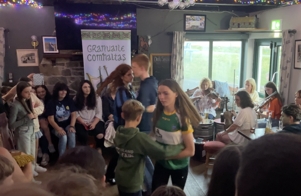
Today, there was a lot brewing at the Clare Island Community Centre judging from the large stack of empty kegs out in front. The usual community center fare of basketball and bingo nights back home apparently gave way here in Ireland to beer and, well, more beer. At 9pm, the centre was packed, literally shoulder to shoulder to make room for traditional Irish music and dancing. At this point, we had succumbed to the Siren call of many an Irish pub laden with ‘Music Tonight’ poster boards, each spot unique and definitely memorable. Here at the community center, all walks of life appeared before us, from long-bearded seafaring wannabes, to hip chino and fancy Italian leather slip-on wearers, to a whole trope of loose cotton frock and dark baggy pant wearing hedonists seemingly walking over from a just-completed group therapy and guitar playing session. And we can’t forget about the perennial all-women midlife meet-up. In our ‘don’t-want-to-miss-out-as-we-won’t-be-back-here-anytime-soon’ mindset, Karen and I had grabbed two of the few remaining bar stools. However, when the pub filled to capacity and an elderly woman stood next to me uncomfortably shifting from foot to foot, I gave her my stool. Many thanks from her and her companions ensued, far more than was necessary as my rear end was getting achy anyway, but it was the pint of Guiness they passed me an hour later that was definitely too much. I had already switched over to my new best friend – Guiness 0.0 – a fine alcohol free offering that I can highly recommend.
Like many pub experiences here, crowd participation is encouraged, or maybe slyly pre-arranged. An older gentleman next to us, who in conversation we found out knows literally everything going on at Clare Island, including having already spotted us on AIS before we pulled in to the harbor, read aloud a poetic story of his days as a young adult on the island. His daughter then stepped up for an acapella performance that quickly hushed any side conversations, pulling in her Eastern European roots in a rendition that had traces of a Fado performance from Lisboa. But the youth traditional dance performance was the real hit, making me recall the ballroom dance class my Mom signed me up for in early high school and the awkwardness of ‘Do I make eye contact with the girl I’m holding right now, so close, and whom I kinda really like, or is she meant to be just a prop for me, and I for her, so we can learn the steps and make our parents, the one’s with this insane idea, proud?’ Alas, everything about high school was slightly awkward, so these moments just flowed right along, like the wind blowing us down the coast of Ireland.

Before we took our leave of Clare Island, Karen and I ventured out of town by foot in search of an old abbey where Grace O’Malley was purported buried. These old structures are clearly an important part of the historical record for Ireland’s people. But they present a challenge, as the centuries of weather-induced decay take their toll. To fully preserve them can be a princely sum and we all know these governments are stretched to spend their people’s money responsibly, with so many competing interests. This abbey had received a new roof, critical to reduce further decay of beautiful stick-figure like paintings on its ceiling. The use of photography inside was strictly forbidden, and a complex apparatus of ventilation had been tucked into the corners to control excessive humidity.
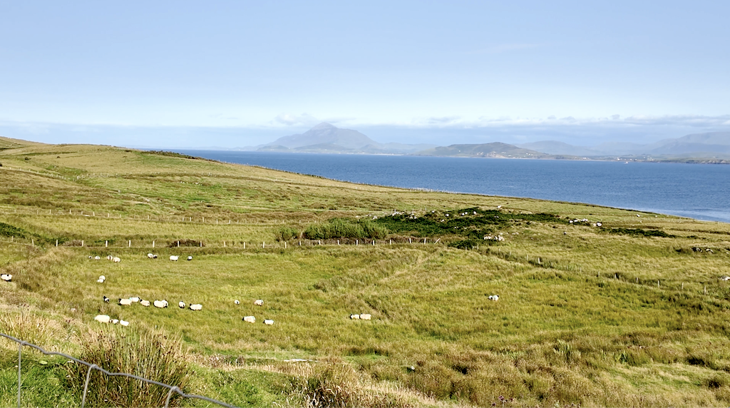
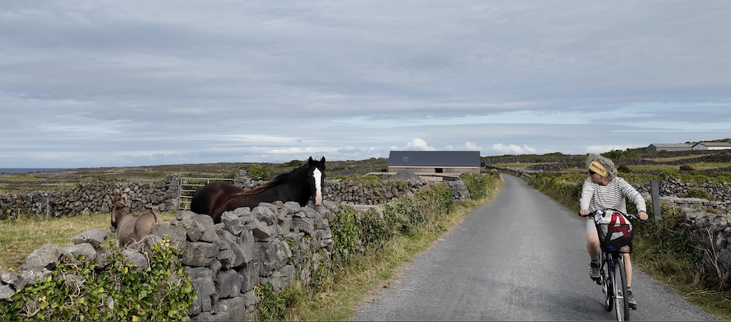
On our return to the harbor, large fields of grazing sheep bordered both sides of the road. We passed a young farm hand repairing a fence in a field overlooking a bright blue sea to the south, with the sun low in the sky amongst puffy white clouds. He had two sheep dogs with him, and they ran ahead to round up all the head of sheep in the field, a masterful instinct in these dog which left us in awe. With his short list of verbal commands, the dogs traced all sections of the field of high grasses and gulleys to make sure no sheep was left behind, where upon the sheep were hustled through a gate, across the road, and up to a small pen for the night. To have this view as your office, and two faithful dogs as your work colleagues, I thought his job was not such a bad gig. If he could pull off a solo performance at the pub, he’d have every woman on the island swooning!
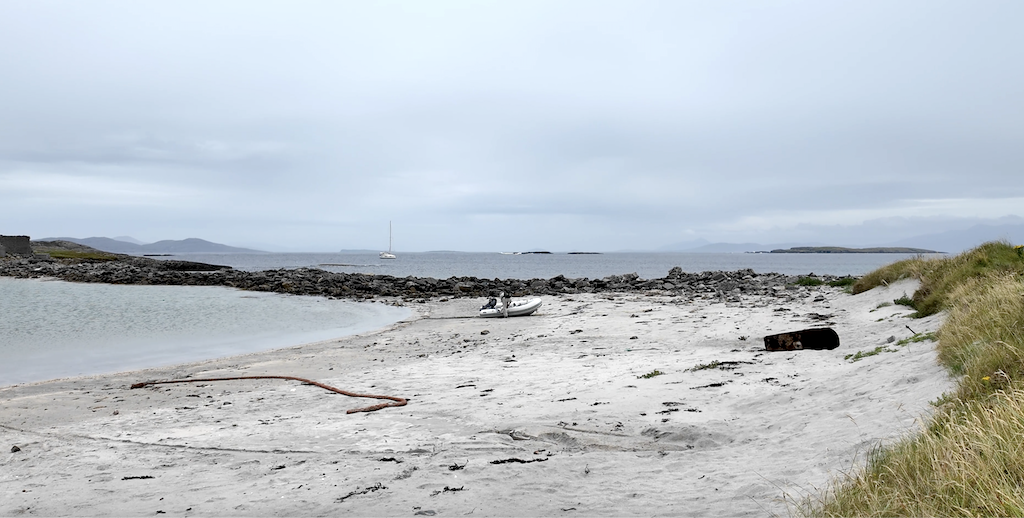
After a restless night of hearing our bow banging into the rigid mooring buoy, we groggily reassumed our progress south. With continued fuel rationing, we killed the engine promptly once clear of the harbor and picked up a light following breeze, pushing us along at 2-3 knots. We would never do this on a normal day. At anything below 3-3.5 knots of boat speed, we would be reaching for the engine’s ‘Start’ button and getting along to our destination with the need for patience. But the lack of diesel refueling options brought a renewed appreciation for the art of sailing, and the art of embracing the present. I kept trying to reinforce in my head, “It is the journey, not the destination” but when what little wind we had dropped off, it was time for a slow motor to our destination for the night, the island of Inishbofin. Despite the calms, higher wind was expected overnight, driving us to select a less frequented anchorage on the eastern shore, that, on first impression seemed to be chock full of rocks and shallows, followed by a tempting gently curving sand beach and a single row of cottages ringing the perimeter.
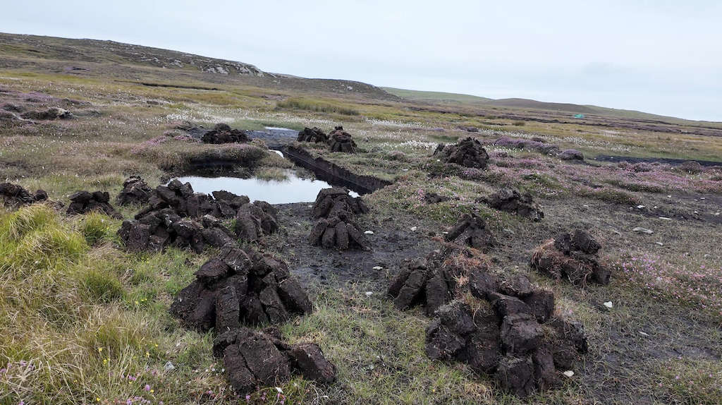
Once settled, we beached the dinghy behind the remains of what must have been someone’s dream house out on the end of a stone jetty, but was now in skeletal ruins, slowly being given back to Mother Nature. Like Clare Island, summer was still in full swing here, with families on bikes and walkers returning from a dip and a tan at several beach venues. For the full time residents, life here was unavoidably hard-scrabble. At the ferry landing, a line of parked cars with flat tires and weeds growing up the sides spoke of a tourism trade balanced with commercial fishing that didn’t quite meet the golden dreams of the islanders. The scenery certainly made up for any financial drought however. We followed one of several well-marked walking paths, joined by families with small children, young lovers, and a few solo hikers out to the ‘West Quarter’, passing large peat harvesting fields, an Irish tradition that goes back to its poorest years. It’s been discovered now that burning peat for home heating, as well as other uses such as tantalizing smoky whiskey, releases more carbon into the atmosphere than can be recaptured in the soil. The peat harvest has since been heavily restricted. Perhaps the authorities have looked the other way and bypassed the inspection rounds here on Inishbofin.

With the core island visitors having caught the last ferry back to the mainland, our return walk was a quiet one with just a few merchants and cafe owners cleaning up with their open signs still out. The temptation to stop was weighed against a steady drizzle – the first signs of the heavier winds forecasted for the evening – and a long walk to a dinghy beached back when it was high tide. We opted for a steady pace home along a road only shared with one other, a child on their bike outpacing their mother, both of whom looked eager to hang up their wet clothes and get warm inside too. Summer in a wet climate like this can take a thousand forms from daybreak to day’s end.
From Inishbofin, the coastline of Ireland opens up substantially into Galway Bay, headed by the popular city of Galway. Countless local Irish sailors, hearing that we were headed down the west coast, highly recommended we stop in Galway. But it is more attractive from the land than from the sea. By that I mean it is stationed some 30 miles deep into the coast. I’m sure we missed a pub or two by skipping the town, but we made up for it by visiting the equally popular Aran Islands, located with more geographic appeal out in the middle of Galway Bay. It would be a haul from Inishbofin and the importance of getting there in a one day shot was fortified by another strong blow from the south forecasted for the following day. At times, pursuing a course south along the west coast of Ireland felt like walking up a bowling lane with Thor and other Greek gods of the weather periodically launching a bowling ball at you, causing a frantic effort to escape its trajectory.
After a much more restful night on anchor (without a mooring buoy striking our hull), we set off at 7am in drizzle and a light headwind. With a long way to go, it is no fun to have a slow start. It kind of feels like running into a chatty neighbor on a Saturday morning already packed with a long list of yard projects. We tacked to windward, rounding a point of land just ahead that deserved a wide berth, with crashing shore waves that looked like they had assumed full-time residence status. As we eased the sheets slightly, Sea Rose was able to gain a bit of speed which was good news as we had just waved to another boat following the same route. We weren’t fooling anyone. Deep down, another sailboat means it’s a race, like it or not. The coast here is pock-marked with off-lying rocks and desolate points of land, one of which is Slyne Head, which we treated with extra respect. Why else would they put two lighthouses on it if it wasn’t an extra danger to coastal navigation?
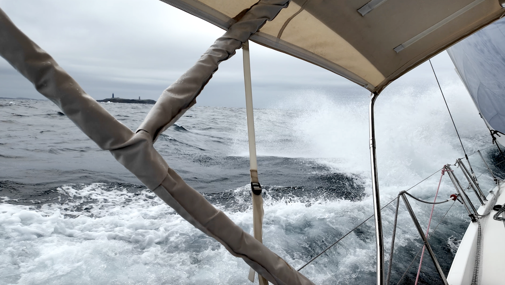
Immediately off Slyne Head, the waves assumed a familiar peaked shape and we were thrashed about as coastal currents collided. Yet, we were cocooned in our comfortable, spacious cockpit while we watched another much smaller traditional sailboat trying to make progress in the opposite direction while being tossed around like the proverbial bobbing cork. A couple of eager crew returning full arm waves affirmed they were genuine card-carrying members, the few, the proud, of the sailing brother and sisterhood.
Sea Rose really shines sailing close-hauled when the seas are cooperating and as the rain clouds were shooed away by sun-drenched skies, the winds increased and what waves existed passed easily under our stern. It was glorious sailing and we could have kept the sleigh ride going all the way into Galway harbor if not for contrary winds coming the next day. Instead, we stuck to the plan and came racing into Inishmore, the main harbor of the Aran Islands, dropping our anchor in the lee of the land, positioned perfectly for a two night stay out of the way of blustery southern winds.
The Aran Islands are relatively flat, with a long gently sloping rise to dramatic cliffs on their southern shore. They are a geographic extension of the famous Cliffs of Mohr, and a couple of bikes are the perfect form of transportation to them. The only choice to be made is whether to take the Green route, an easier flatter route, or the Red route, which was… okay you guessed it already! For those that were still befuddled, there was the option of a leave-the-driving-to-us traditional horse drawn carriage, conveniently ending at the well stocked, open-air Aran Sweater Market. These folks have mastered the co-marketing trend!
We arrived at the historic Dun Aonghasa site with just enough time for a quick tour before they closed. When the hostess, starting off with the “So, where are you from” introductory opener and learned of our sailing adventure and plans to cross the Atlantic, she was soon summoning her colleague and gushing with enthusiasm to hear about all of the details. When I reached for my wallet to settle the five euro entry fee times two, she insisted that entry was free for the ‘Sailors from America’. For a moment, I envisioned a future of lucrative sponsorship deals that might just cover our expenses, but Karen was quick to shake me back to reality and hustle us along on the self-guided tour.
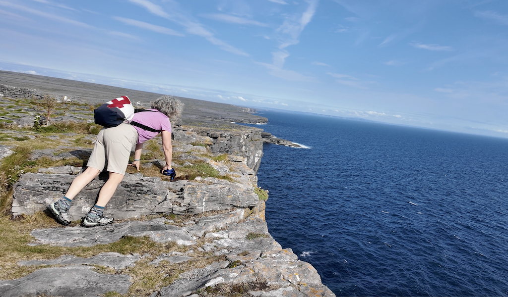
For an American in Europe, confronted with far more centuries of history than our newly minted homeland, it can get taxing to properly digest all the historical sites that – from their plaques, brochures and throngs of people – clearly are of important cultural stead. Dun Aonghasa’s significance as ‘one of the finest prehistoric fortresses in Western Europe’ had to take second fiddle to fascinating views over the cliff edge on this late afternoon gem of a day. Like kids defying their anxious mother’s warnings, we both laid prone on the rock and scuttled forward on our stomaches to glance down at the raging sea directly below, feeling the thud of each wave reverberating all the way back up to us.

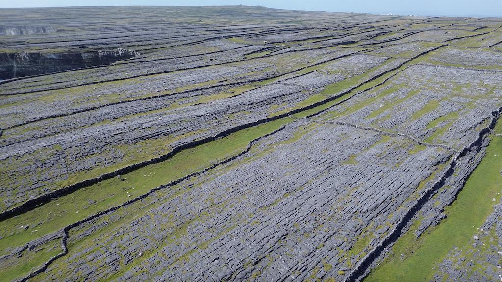
Dun Aonghasa’s four concentric dry stone ramparts were a preview of vast stone works throughout the island. Along both shoulders of the roads were tall stone walls. Perpendicular to these walls were more walls marking off what must have been individual owner’s long ago grazing plots. As far as the eye could see, this island was checkerboarded with stone walls running from south to north, east to west like a densely woven lattice fence, I couldn’t fathom how many person-hours it must have taken to build them all. And equally, why? Could there have been such a tremendous need for grazing animals years ago, and was there such a huge fiefdom that owners couldn’t share one larger plot instead of 20 tiny ones? Perhaps the answers were clearly stated in the visitor center of Dun Aonghasa, collateral damage to our personal knowledgebase on account of our earlier impropriety.

As we make our way further south, we will endeavor to mottle through the lattice work of historical Irish menagerie, revealing to you, dear reader, the most consequential stories. Until then, be sure to check out our latest LifeFourPointZero YouTube video release of sailing around Norway’s beautiful Vieholmen.
